Reflections on CB9, Part 2: Resources
[community-board Hello! This is Part 2 of my blog series reflecting on my time on Community Board 9. If you stumbled upon this post, I recommend checking out Part 1 for context first.
This post compiles various tools, maps, and datasets that I used while serving on Manhattan Community Board 9 (MCB9). Most are zoning-related and invaluable for tracking land use and development. Whether you’re new to the board or simply looking to learn more about land use, I hope this helps you learn more about your neighborhood and saves time.
There’s an immense amount of content, so some structure is in order:
- First, I’ll share a short list of documents and tools I found most helpful for learning about the board and the district. All new board members should familiarize themselves with these.
- Second, I’ll provide a list of land use tools more specialized for members of the Housing, Land Use, and Zoning (HLUZ) committee or anyone interested in land use.
- Third, I’ll explain how these tools can be applied, with a focus on keeping tabs on relevant developments in CB9 and pulling statistics for the CB9 Statement of Needs.
Happy researching!
Contents
- Contents
- Section 1: Essentials for any CB9 member
- Section 2: Land use investigator’s toolkit
- ZoLa: What is the zoning and current use of a property?
- ULURP and ZAP: What’s the status of a rezoning proposal?
- City of Yes: How have the zoning rules recently changed?
- Neighborhood-level zoning documents: What are the housing visions of MCB9 and other local groups?
- DOB NOW: What construction has been approved?
- ACRIS: When was a property sold?
- HPD Online: What building violations are active?
- Housing Connect: Which affordable housing lotteries are open?
- Housing production stats: How much have we built?
- Section 3: Practical fact-finding for HLUZ
- Monthly updates on “Developments we are watching”
- 620 W 153rd St (Sunrose towers) | Recently Completed
- 600 W 125th St (Columbia grad student/faculty housing) | Recently Completed
- 521 W 134th St | Recently Completed
- 1871 Amsterdam Ave | Under Construction
- 1867 Amsterdam Ave | Under Construction
- 1763 Amsterdam Ave | Under Construction
- 1440 Amsterdam Ave | Under Construction
- 3560 Broadway: RKO Hamilton Theater | In Development
- 1727 Amsterdam Ave | In Development
- 633-641 W 142nd St | In Development
- 701 W 135th St (Crosscap ULURP / Amtrak cantilever building) | In Development
- 478 W 130th St | In Development
- 487 W 129th St | In Development
- 16 Convent Ave | In Development
- Annual statistics for CB9’s Statement of Needs
- Monthly updates on “Developments we are watching”
- Wrap-up
Section 1: Essentials for any CB9 member
Before diving into specialized land use tools, here are a few key resources that every MCB9 member should be familiar with. These links and documents govern how the board operates and define its core responsibilities.
MCB9 website: cb9m.org. This is the primary source of information for CB9 matters, where you can find the meeting calendar, most meeting minutes (on each committee page, e.g., here for HLUZ), some resolutions (also on committee pages), a list of all board members, and links to key documents and resources.
One particularly important reference is the by-laws, which govern how MCB9 operates (e.g., how board leaders are elected, how resolutions are passed, and how attendance is enforced).
MCB9 Youtube channel: All meeting recordings are posted here, in case you missed anything or wish to revisit a particular conversation. You can also search AI summaries of publicly available meetings at websites like block party and citymeetings.nyc (which mostly covers city council meetings, but includes annotated CB discussions of the City of Yes zoning text amendments).
Community Benefits Agreement (CBA): This 2009 agreement between MCB9, NYC, and Columbia University outlines Columbia’s obligations in exchange for zoning changes at its Manhattanville campus. This funding includes $76M for a benefit fund, disbursed to local organizations by the West Harlem Development Corporation (WHDC); $20M for an affordable housing fund; $4M for tenants’ legal services; and $20M in in-kind benefits. These in-kind benefits provide community organizations access to Columbia facilities and can be requested with this form. (The SGL-LGBTQ task force has used these benefits to hold outreach events at The Forum.) Plans for the Manhattanville campus are found here.
Much of MCB9’s work relates to the CBA: the board appoints members to the WHDC, the Strategic Planning Committee helps oversee the agreement, and other committees regularly hear reports from funded non-profits. Most CB9 members would benefit from skimming the agreement and having easy access to it as needed.
Recently, there has been talk about amending the CBA. These efforts, largely spearheaded by State Senator Cordell Cleare and the One Harlem Coalition, include legislation that could nullify the existing agreement and initiate negotiations for a new one.
MCB9 district profile: The city produces these profiles as a clearinghouse of key demographic information for each community district (e.g., age, gender, race/ethnicity, rent burden, unemployment, commute time). Note that some demographic info on the profile is outdated; the most current data is reflected here.
It also includes links to the MCB9 Statement of Needs, a formal document drafted by MCB9 each fall that makes funding requests to city agencies for capital and operational expenditures. All committees are responsible for writing certain sections. (This post will later discuss how to pull some statistics for the housing section.)
Section 2: Land use investigator’s toolkit
A huge part of serving on the board (especially the HLUZ committee) involves investigating specific properties and proposals. Here’s a guide to the land use tools that will help you find answers.
First and foremost, I have to mention the tremendously helpful HLUZ FAQ, which defines many acronyms and provides context about HLUZ’s vision for housing in MCB9.
ZoLa: What is the zoning and current use of a property?
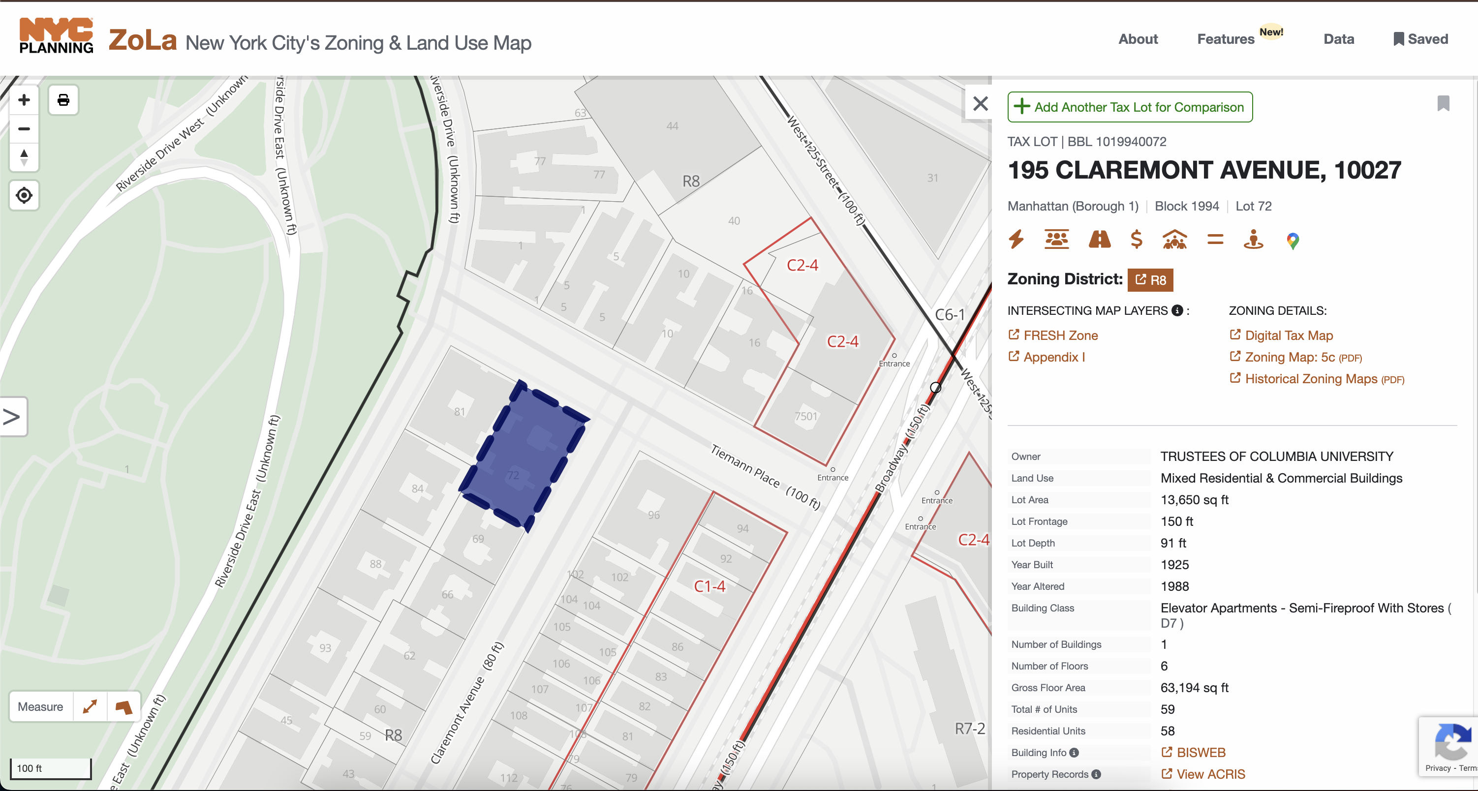
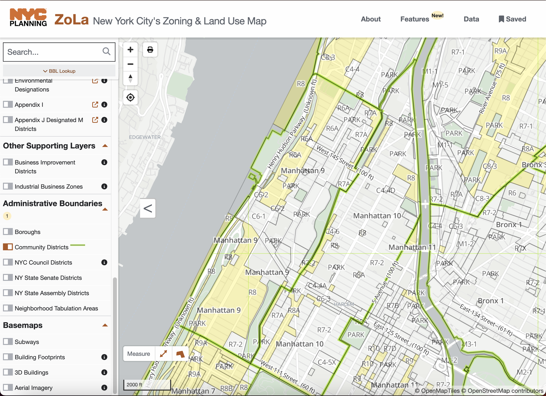
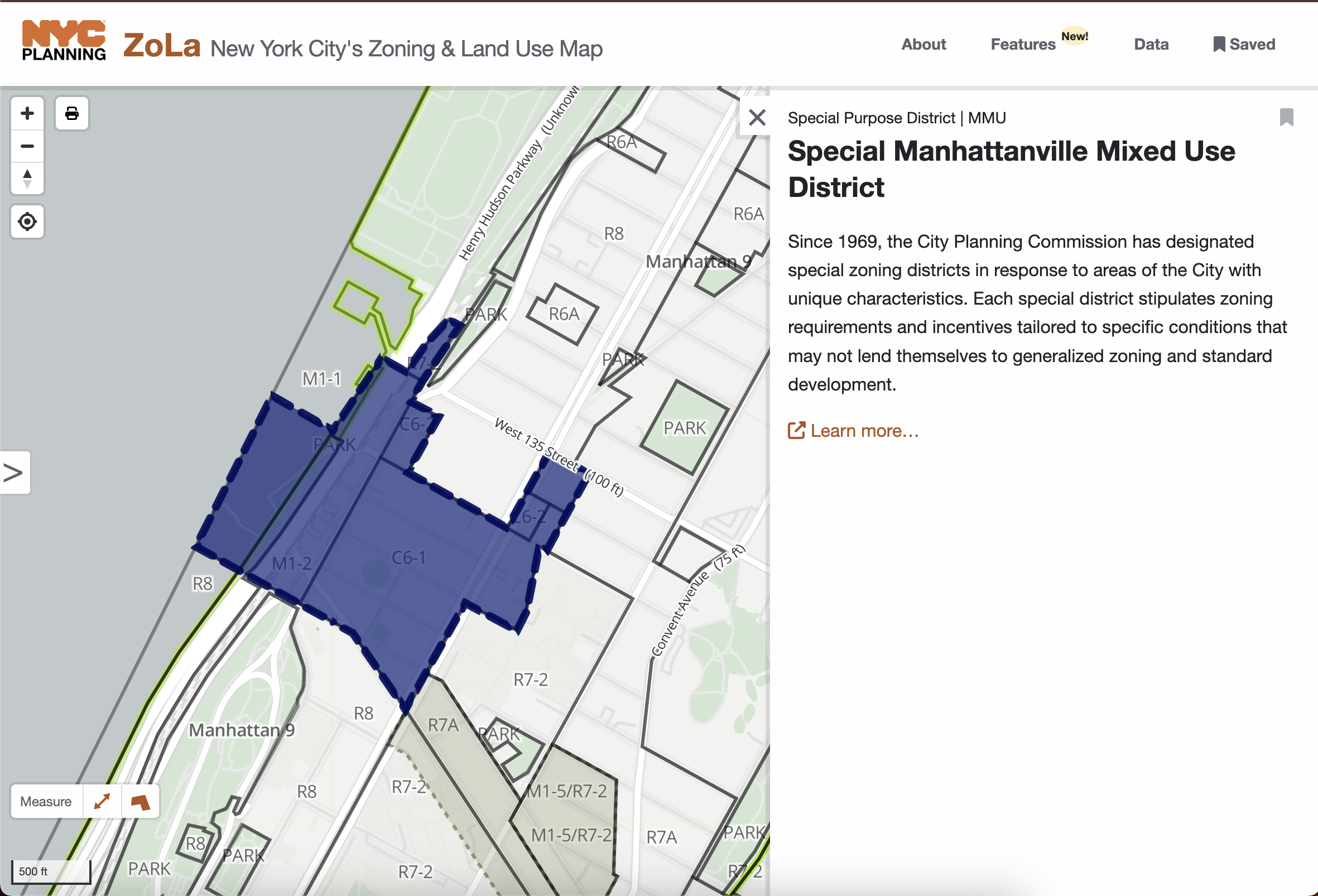
Zoning specifies what kinds of buildings can be constructed as-of-right (i.e. without requiring formal approval from the Department of City Planning – DCP and the City Council) in various districts. ZoLa is the most helpful tool for exploring the city’s zoning geography. As a map nerd, I also find it incredibly cool and fun to use. ZoLa contains maps of all zoning districts, down to the building-level. Here how you can use it:
-
Check ownership and zoning info for a particular building. For instance, at 195 Claremont (my old address), you can see its owner (Columbia), the number of units, the zoning district (R8), and links to tools like ACRIS (for ownership information) and HPD Online (for building violations).
-
Use filters to visualize the different types of development that are permitted in different parts of MCB9. For instance, this link visualizes all areas where dense housing (R8 and up) are permitted.
-
See the boundaries and documentation of special land use districts, such as the Special Manhattanville Mixed Use District, created to facilitate Columbia’s Manhattanville expansion.
When using ZoLA, I frequently consult documentation of what each zoning designation permits and prohibits.
ULURP and ZAP: What’s the status of a rezoning proposal?
The Uniform Land Use Review Procedure (ULURP) process initiates whenever a proposal seeks to change zoning in a particular area. After DCP pre-approves an application, the community board has 60 days to hold a public hearing and provide its recommendation. This PDF offers a nice visualization of the process.
The status of ULURPs can be tracked on the Zoning Application Portal (ZAP). ULURPs may involve “spot rezoning” a specific site (e.g., the “Amtrak cantilever” 135th St Rezoning) or city-wide, broader text amendments (e.g. City of Yes Housing Opportunity). Most relevant documents (site plans, past resolutions, etc.) can be found on the ZAP page under “Public Documents.”
City of Yes: How have the zoning rules recently changed?
Speaking of City of Yes, familiarity with recent and ongoing zoning changes is crucial for understanding what can and cannot be built. City of Yes was a three-phase program by Adams administration, enacting city-wide zoning text amendments for Carbon Neutrality, Economic Opportunity, and Housing Opportunity. Our resolutions are linked here: carbon, economic, housing.
The actual text amendments are incredibly long (see here for almost 1400 pages about housing), but the DCP website offers documents that simplify processing, such as this slide deck on CoY Housing Opportunity’s effects on CB9. Notably, changes for CB9 include the elimination of parking mandates and the Universal Affordability Preference (UAP), which permits additional residential floor area for affordable units.
A few other recent or ongoing planning changes may be worth checking out:
- The Green Fast Track for Housing, enacted in 2024, allows expedited environmental review for residential buildings that meet certain environmental standards.
- The Manhattan Plan, which aims to produce 100K new housing units in Manhattan. This is very early in the process (as of summer 2025) and may not have any relevant changes for MCB9.
Neighborhood-level zoning documents: What are the housing visions of MCB9 and other local groups?
A few other zoning documents and proposals pertain specifically to MCB9 and are relevant to HLUZ work:
- The 197-a plan, a 2007 document outlining MCB9’s housing priorities. (Chair Victor Edwards recently stated his desire to see this document updated.)
- Several plan items, such as adopting contextual zoning, were accomplished in most of the district by the 2012 West Harlem rezoning.
-
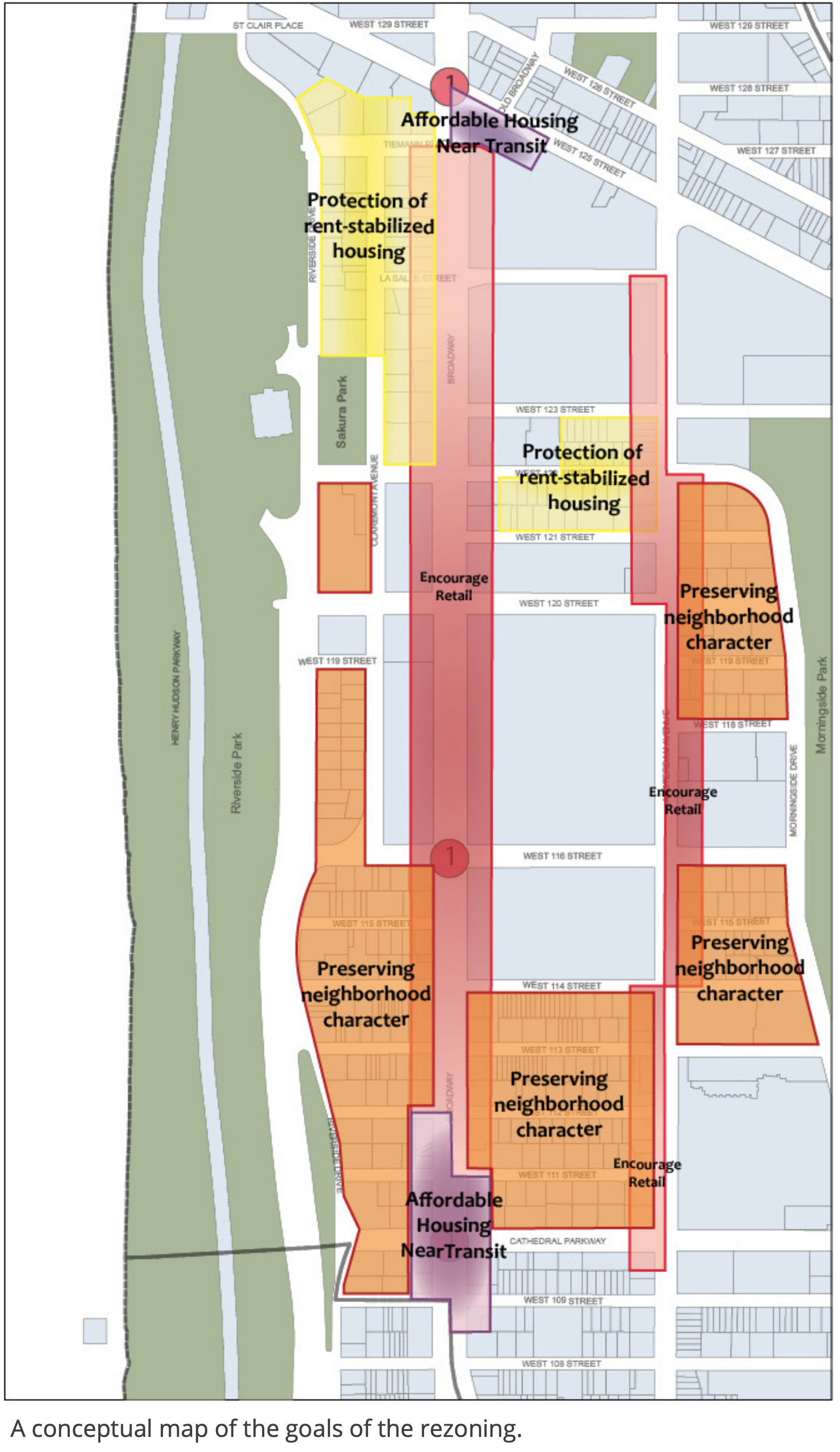
For several years, MCB9 has sponsored a community-led rezoning of Morningside Heights, facilitated by the Morningside Heights Community Coalition. A planning study drafted several aims: producing affordable housing near transit, downzoning areas with high concentrations of rent-stabilized tenants, promoting retail along Broadway and Amsterdam, and adopting contextual zoning throughout much of the neighborhood.
- The borough president’s office produced a “Housing Manhattanites” document identifying potential sites for new homes in each community district. It highlights the Morningside Heights rezoning and additionally suggests the bus depot at 1381 Amsterdam Ave could be repurposed into up to 430 affordable units.
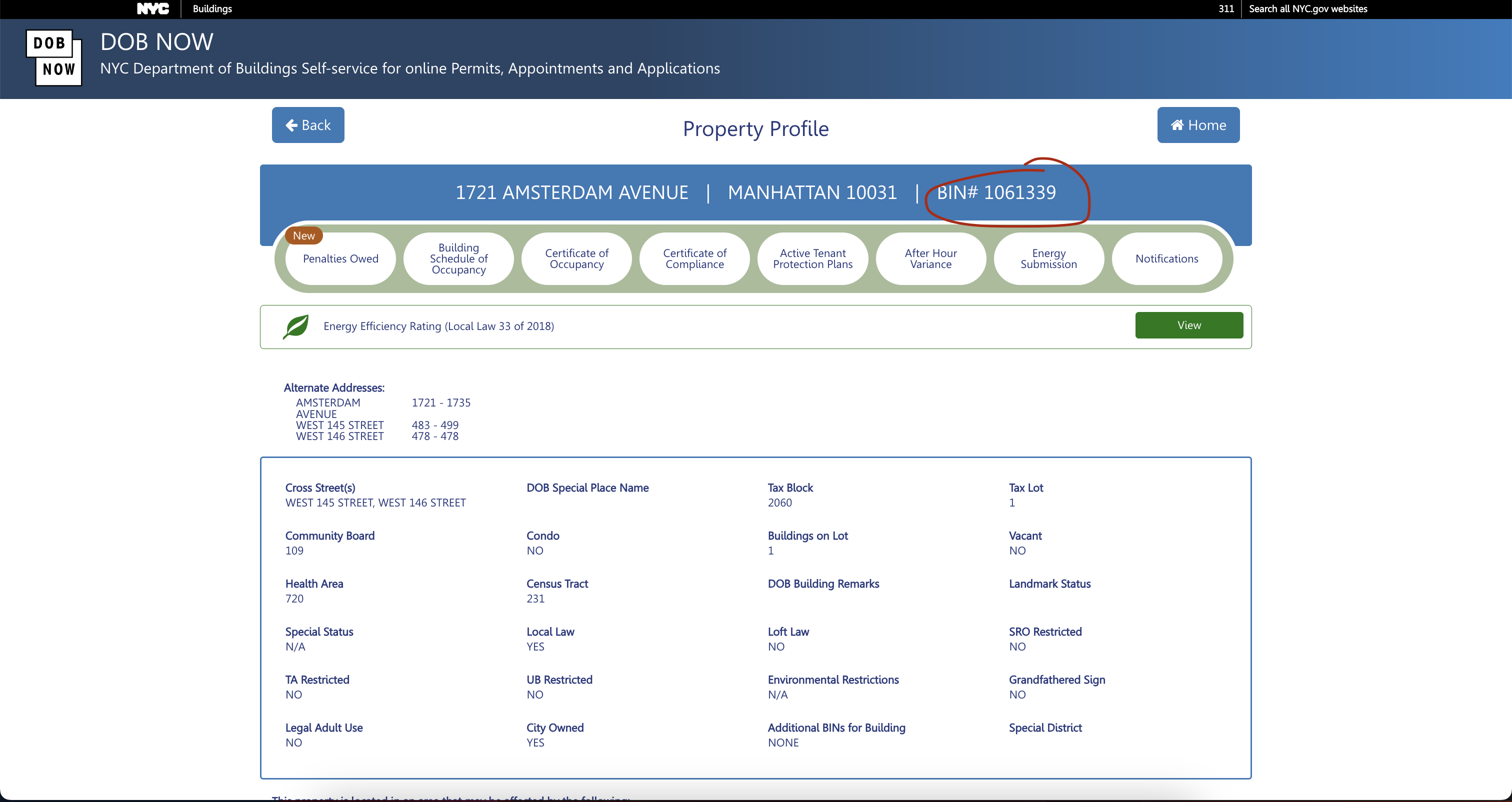
DOB NOW: What construction has been approved?
Use DOB NOW to find Department of Buildings permits for any site. You can search by address or Building Identification Number (BIN) for detailed information about the status of relevant construction and demolition permits.
Note: If you use DOB NOW frequently (like me), it becomes much easier to copy-paste BINs than to search for each address. I would recommend keeping the BINs you care about in some document for quick searches. (See below for where to find BINs.)
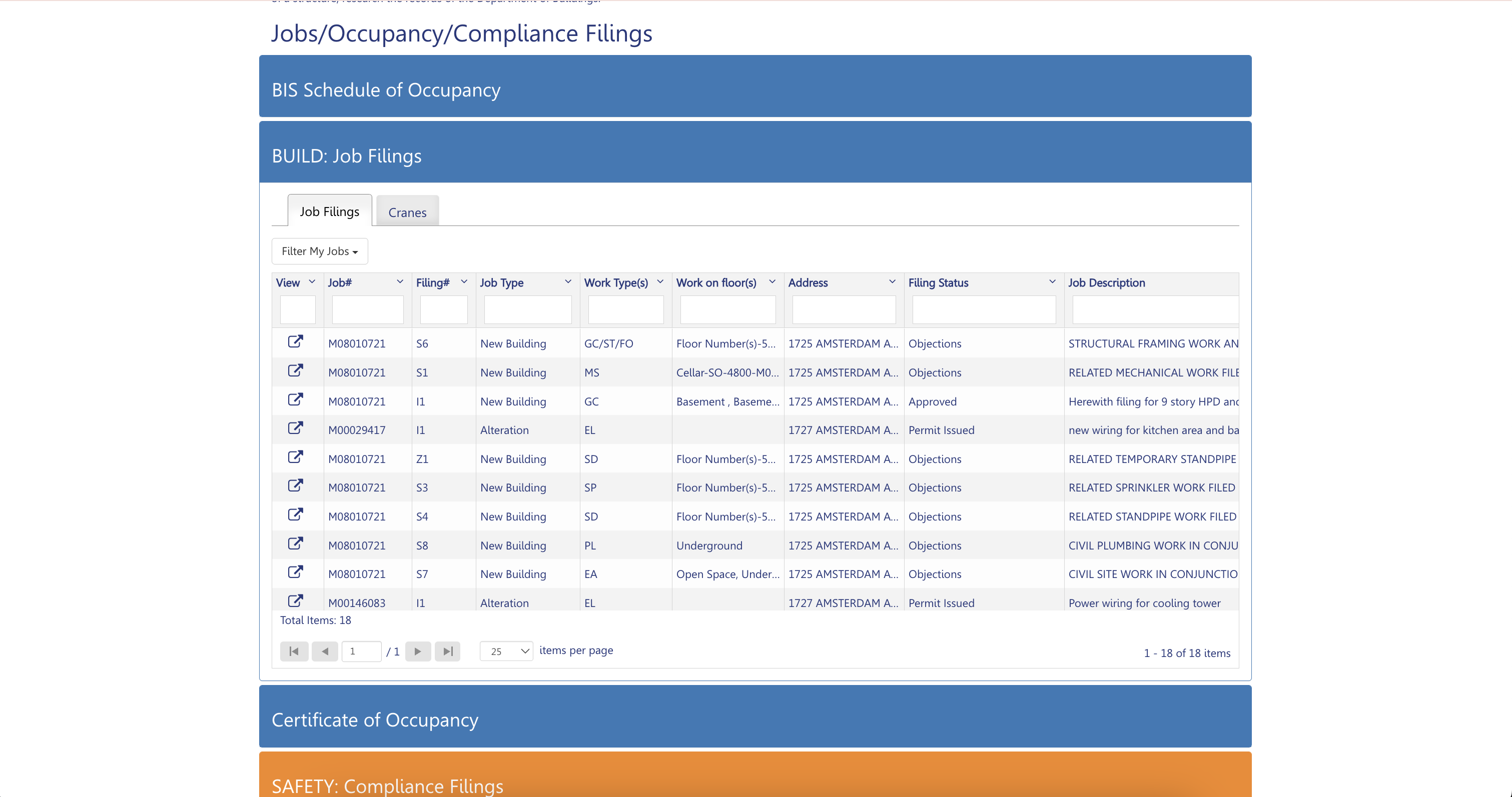
To find the most relevant information, scroll down and click “BUILD: Job Filings.” Here, you’ll find a list of permits with details about their status, work type (note “GC” = “General Construction” and “FD” = “Full Demolition”), and filing status. This document explains each filing status; this page details job types. I typically clicked the “Modified Date” column on the right to sort permits with the most recent ones first.
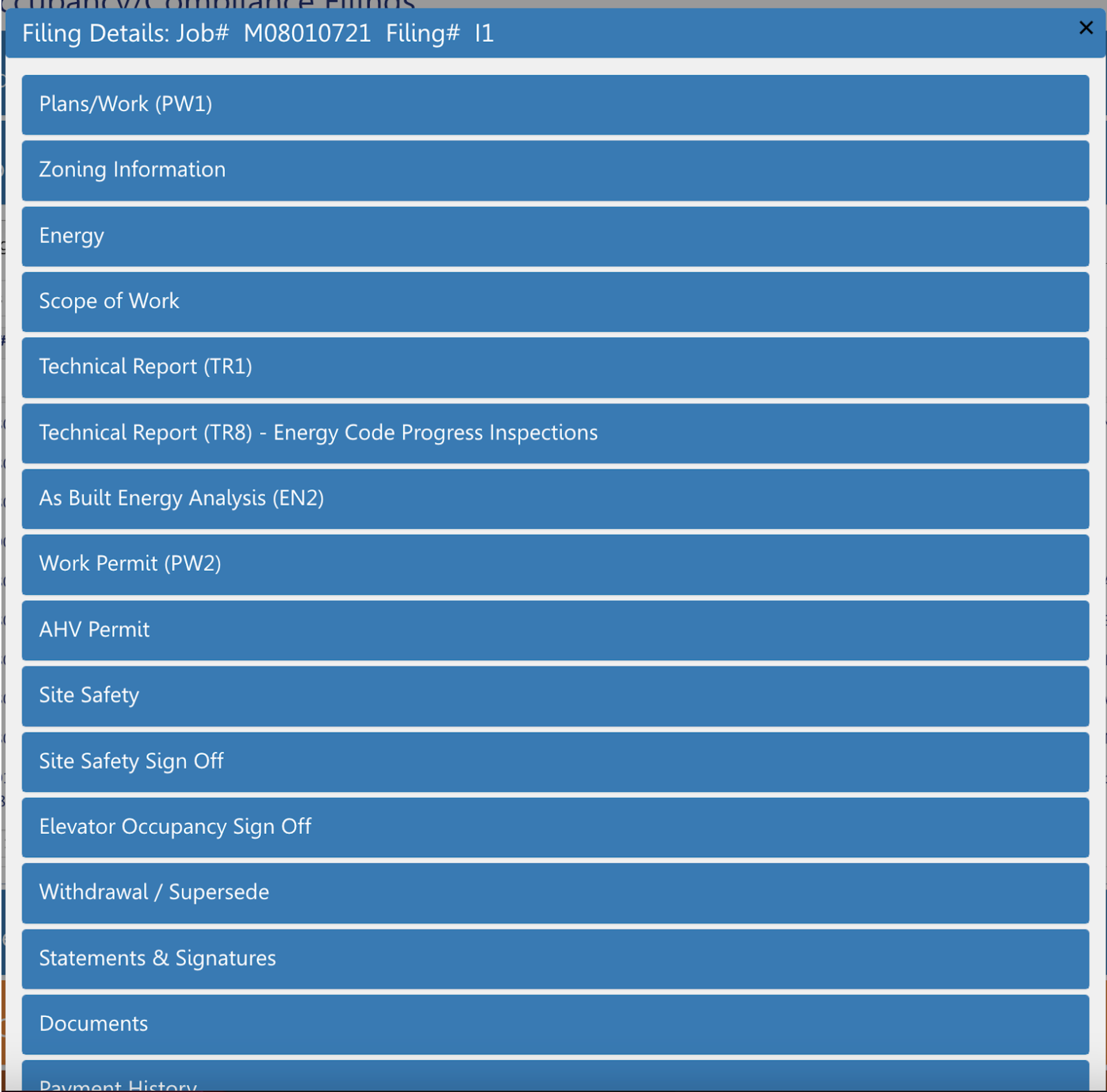
If you click on the “View” icon on the left, you’ll find a new menu with a lot more information about what the permit is for. This is typically where we can find out the plans for a new building. You sometimes need to explore closely for information, but in this case, you can find a schematic of the proposed building under “Documents” > “ZD1: DOB Zoning Diagram.” “Zoning Information” includes the proposed number of units, floor area, and height.
DOB Now is excellent for looking up a particular building’s status, not for finding all new construction permits in MCB9. You should instead look at this OpenData table on building permits. This huge spreadsheet contains the status of all city-wide building permits. You can create a custom view of the table by applying filters.
- Click “Actions” > “Query data” to view a spreadsheet with a record of every building permit issued in NYC. This raw data, spanning over 7,600 pages, is unusable without filtering.
- First, filter by CB9 permits. Find the “Select a column to filter” button at the bottom and choose “Community - Board.” Enter “109” (Manhattan = “1”, CB9 = “09”) to restrict the search to MCB9. Press “Apply.” This narrows the results to 81 pages.
- Most permits apply to minor alterations and can be ignored. Restrict the scope to new construction and full demolition by clicking on the “+” button below the previous filter and selecting “Job Type.” Then, enter “Full Demolition” and “New Building.” This narrows the results to 2 pages.
- Finally, sort by “Current Status Date.” The easiest way is to scroll horizontally across the table until you find the column, and press its options to select “Sort Descending.”
Thankfully, if you don’t want to do that (or only want to do it once), you can save a set of filters by simply copying the URL that links to your customized table view. This (extremely long) URL extracts a query of MCB9 full construction and demolition permits directly. OpenData is helpful for many many other things, and it will be revisited later.
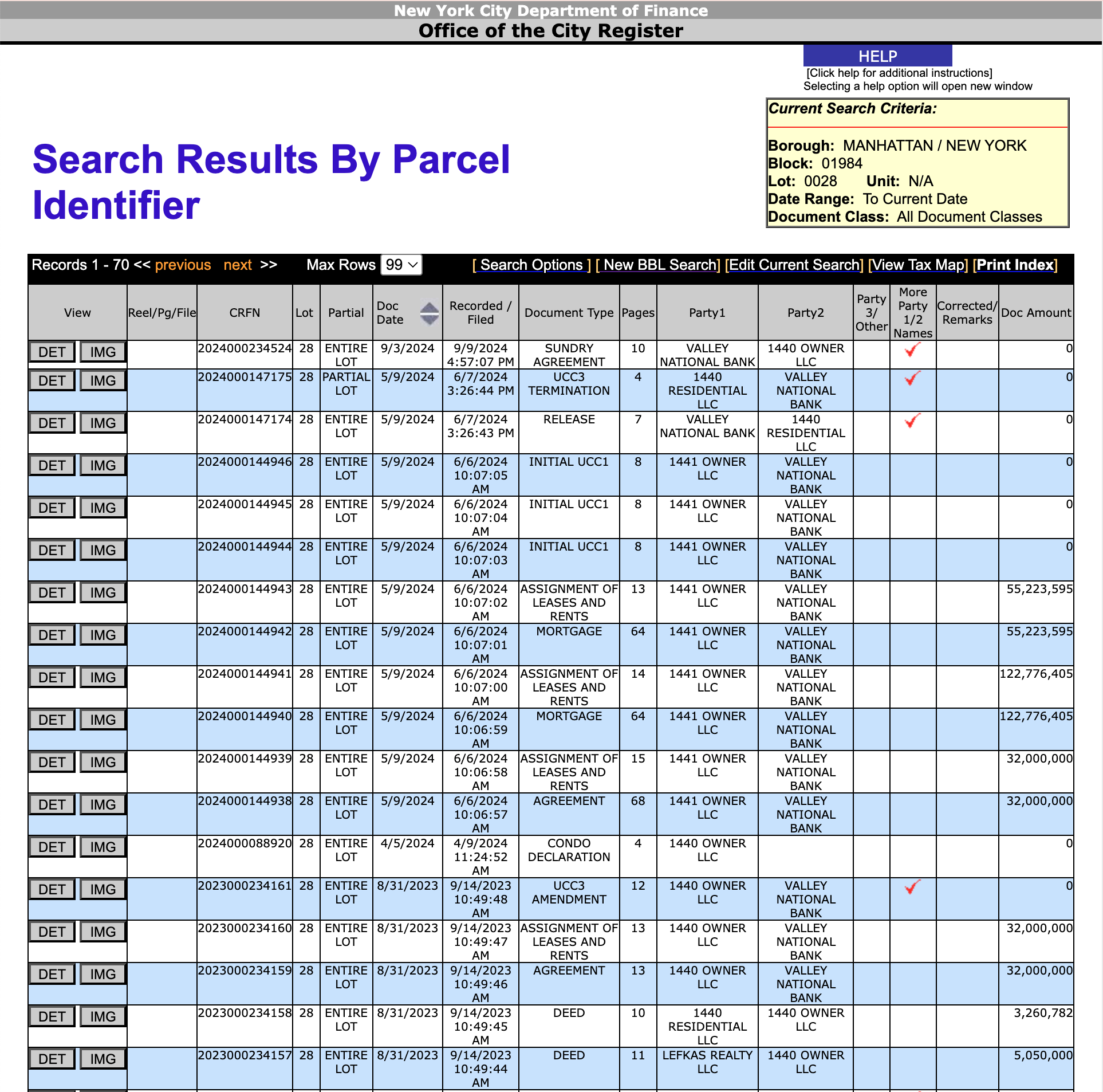
ACRIS: When was a property sold?
The Automated City Register Information System (ACRIS) monitors changes in property ownership. Unfortunately, ACRIS is a pain to use, with a dated user interface.
To search records for a specific address, first retrieve the block and lot numbers by navigating to “Find Addresses and Parcels” and entering the address.
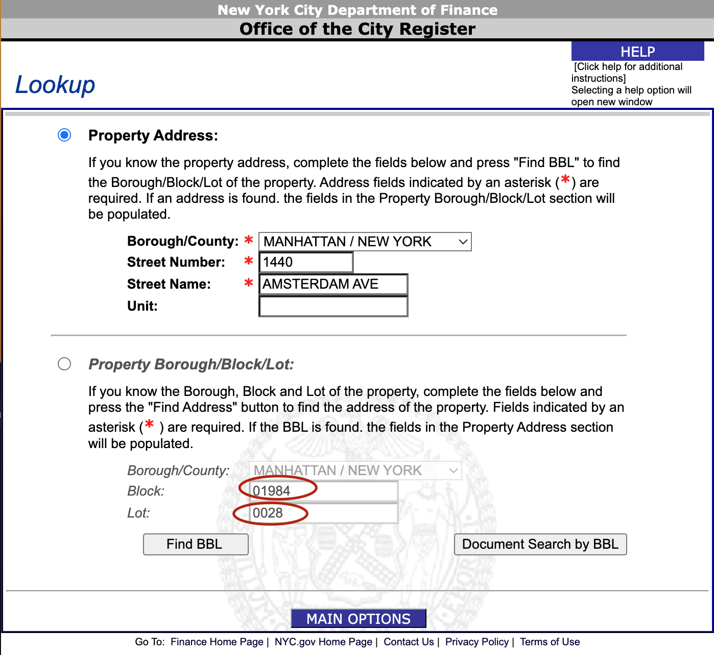
Then, return to the homepage and navigate to “Search Property Records.” Enter the borough and the two numbers to get a list of recent property records, including dates, parties, monetary amounts, and documentation.
HPD Online: What building violations are active?
HPD Online contains searchable records of building violations. Fortunately, it’s much easier to use than ACRIS. Simply search the address (or enter the BIN) to find information about complaints, violations, fees, litigation, and rent regulation.
To see all of the data, access the Housing Maintenance Code Violations OpenData table. Like the DOB NOW table, you can use filters to restrict the database to relevant violations. We use this table annually for our Statement of Needs, a topic discussed later.
Housing Connect: Which affordable housing lotteries are open?
All affordable housing lotteries are organized through Housing Connect. HLUZ members find it valuable to track ongoing lotteries in MCB9. Press “Open Lotteries” and use “Refine Search” to restrict the lotteries to Manhattan. At the time of writing, a single open lottery existed in MCB9 at 1471 Amsterdam.
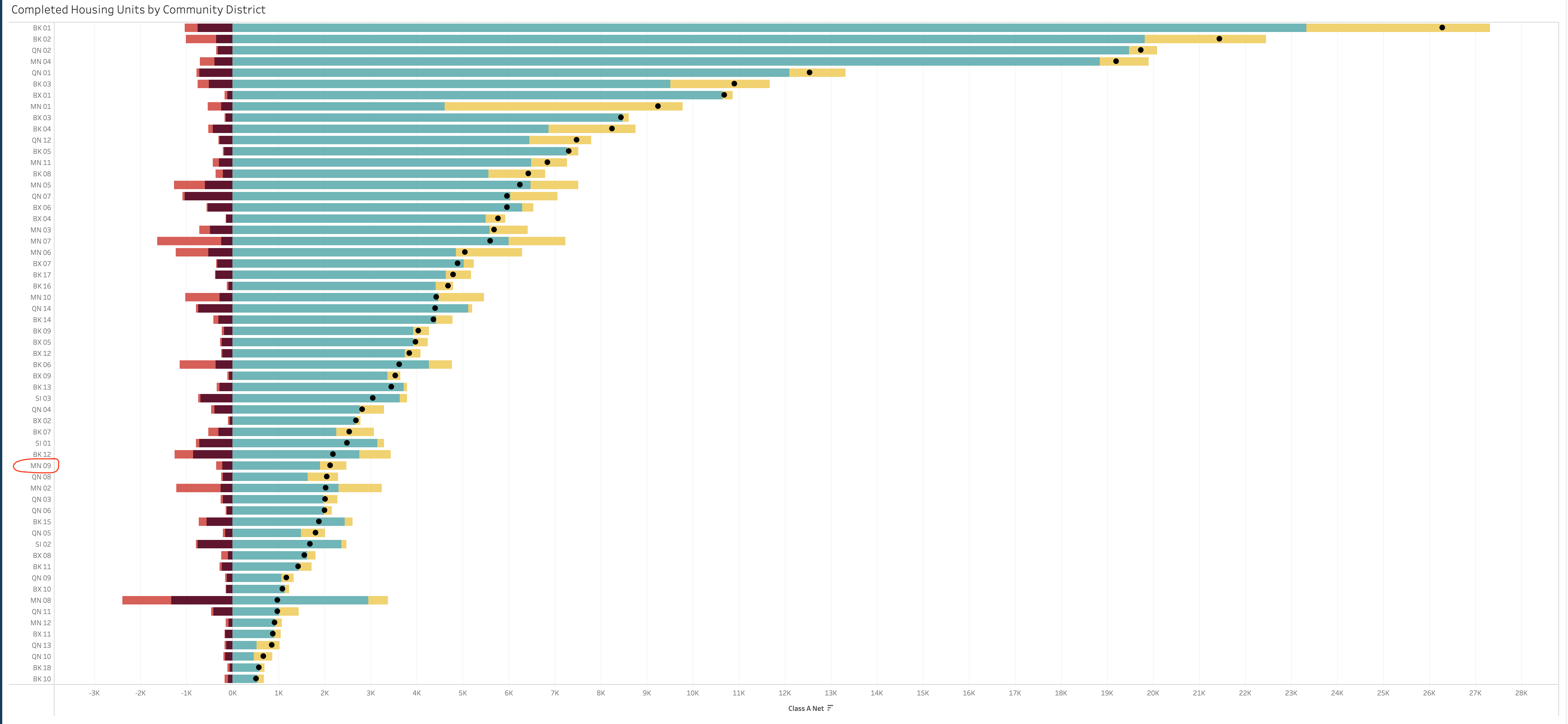
Housing production stats: How much have we built?
There are several sources of information about housing production numbers, broken out by district. DCP has several useful dashboards:
These offer helpful plots for understanding how MCB9 stacks up relative to other community boards. Below is the total number of total new units between 2010 and 2023:
This tracker shares district-level vacancy rates and affordable housing construction.
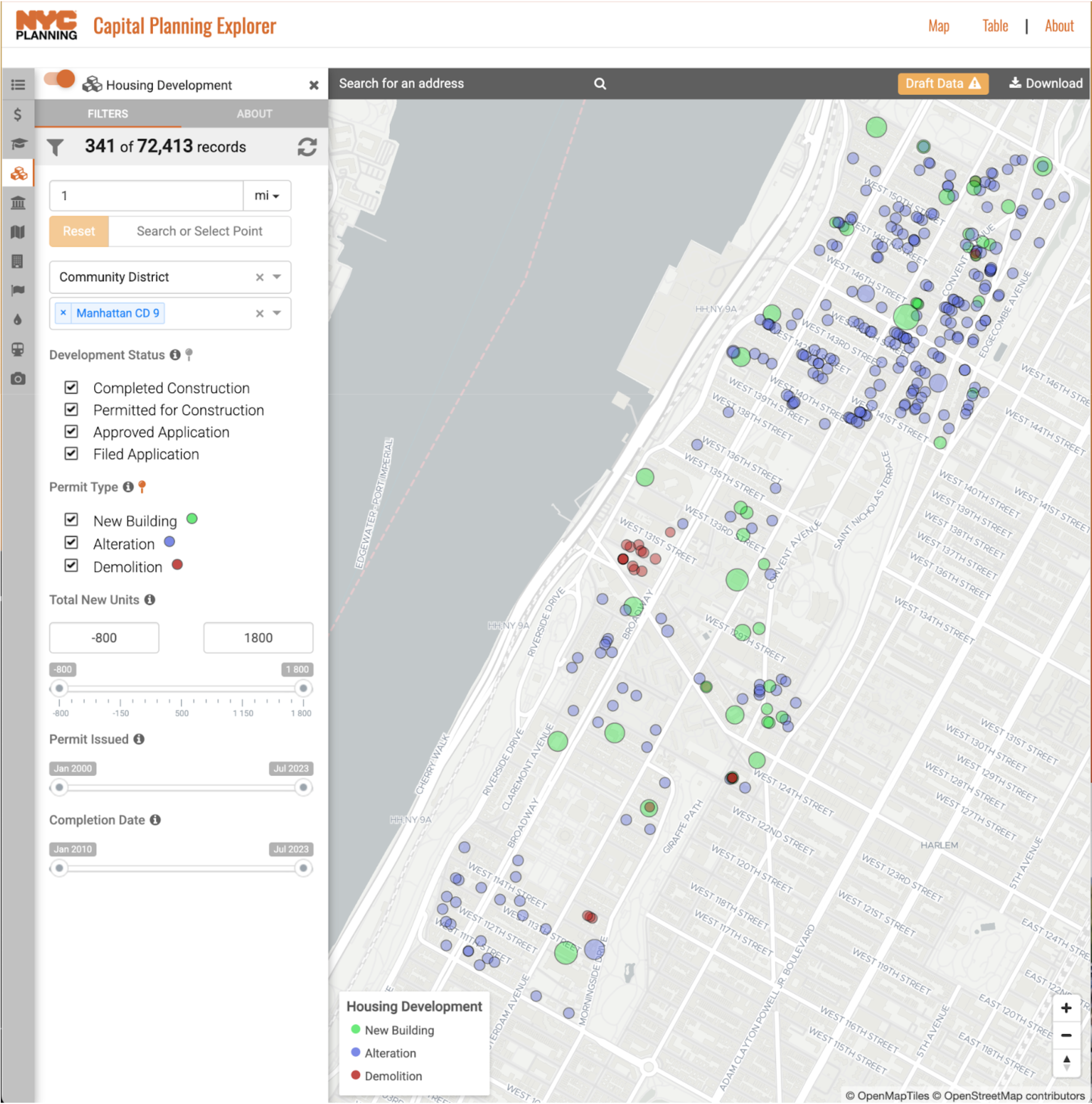
The Capital Planning Explorer map visualizes net increases and losses in units by building.
This OpenData table breaks down affordable housing production by building and by district, powering the above visualizations. By adding a “MN-09” filter under “Community Board” and sorting by “Project Completion Date,” you can generate a table showing new construction results with a breakdown of units by affordability status.
Section 3: Practical fact-finding for HLUZ
Knowing the tools is one thing; using them effectively together is another. In this section, I share specific recurring tasks I performed for the HLUZ Committee that required combining multiple resources to get a complete picture. This section is split into two parts:
- The first covers my monthly updates to the Housing, Land Use, and Zoning (HLUZ) Committee on particular sites under development or construction.
- The second explains how to find updated housing statistics for the annual MCB9 Statement of Needs.
Monthly updates on “Developments we are watching”
I prepared monthly updates for the HLUZ Committee to share information about the status of various properties in CB9. I’ll share which of the tools I used, in case that may be helpful for whoever takes on that responsibility next year.
Before each meeting, I took the following steps:
- Scanned a list of new construction and demolition permits issued in the previous month, using this OpenData query (explained in the previous section).
- Checked the permit on DOB NOW if anything seemed out of the ordinary, by searching for its BIN and reading the included information. This helped confirm the number of units, height, and current status.
- Found updates on ongoing ULURP applications by using ZAP. This link leads to a page of all filed and ongoing ULURP procedures in MCB9. (As of writing, none are active.)
- Checked for new affordable housing lotteries on Housing Connect.
- Went for a run around the neighborhood! This optional step helped me check out sites under construction in person, providing a clearer idea of the current status. (As MCB9 Chair Victor Edwards often says, board members are the eyes and ears of the community, and there’s much to learn by walking the district’s streets.)
Now, I’ll provide a fairly long list of the sites that we looked at, noting relevant CB9 resolutions and basic factual information. To keep this from becoming impossibly long, I’ll refrain from extended commentary about each.
The below map visualizes the relevant sites:
620 W 153rd St (Sunrose towers) | Recently Completed
Approved for construction as-of-right. This building’s form may be illegal under contextual zoning rules. It is still regularly discussed at the board as a result.
| Website | https://sunrosetower.com/ |
| Google maps | https://maps.app.goo.gl/U1YYxuqqxnsz1LCo8 |
| BIN | 1091769 |
| Units | 238 |
| Zoning | R8 |
| Completed | 2023 |
 Source: sunrosetower.com
600 W 125th St (Columbia grad student/faculty housing) | Recently Completed
Part of Columbia’s Manhattanville campus.
| Website | https://residential.columbia.edu/content/600-west-125th-street |
| Google maps | https://maps.app.goo.gl/1EXHUnrANvDQJZet8 |
| BIN | 1091635 |
| Units | 142 (Columbia affiliates) |
| Zoning | R8 (Special Manhattanville Mixed Use District) |
| Completed | 2025 |
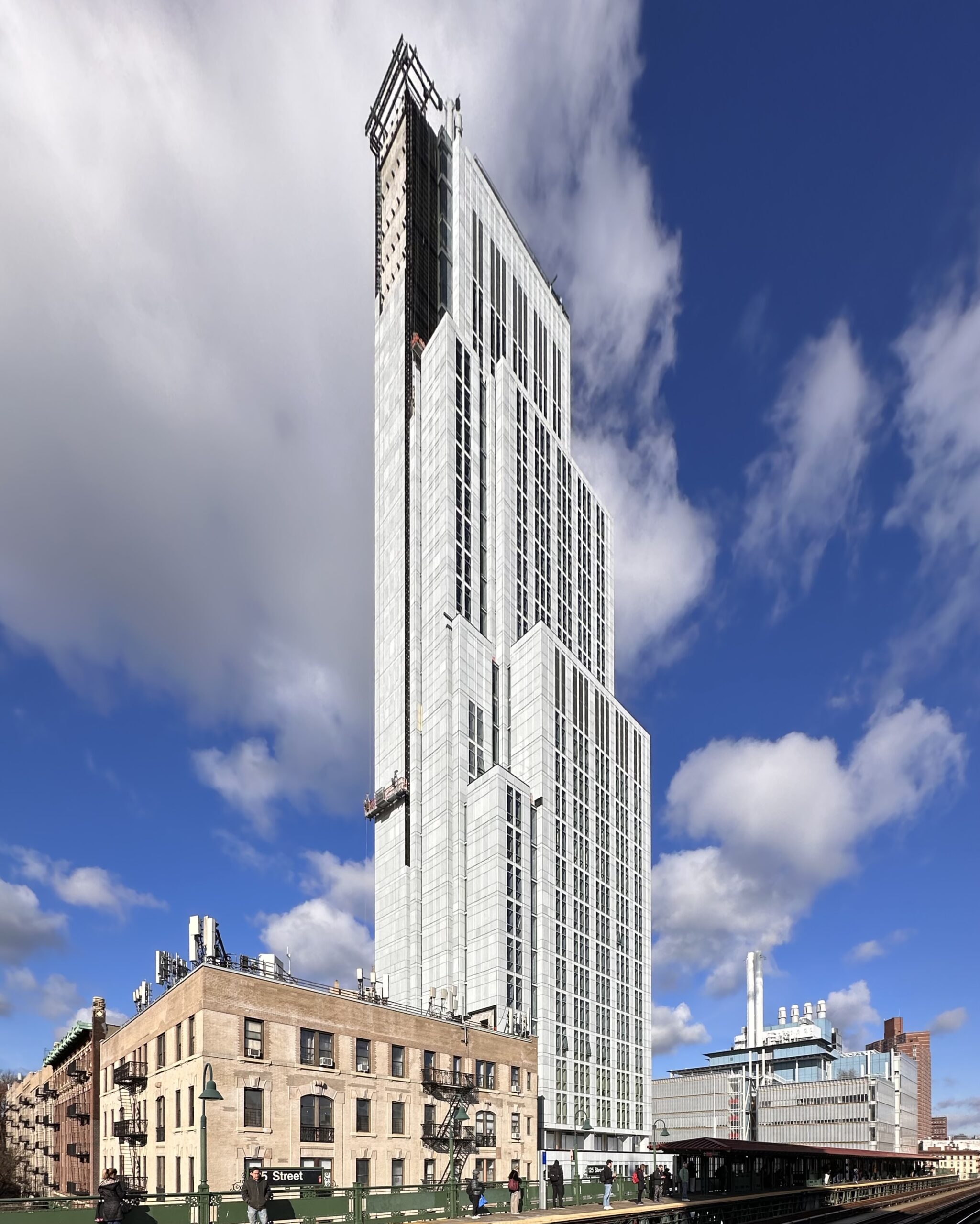 Source: New York YIMBY
521 W 134th St | Recently Completed
| Website | https://www.livingny.com/exclusive-projects/521-west-134th/ |
| Google maps | https://maps.app.goo.gl/e7YrHUY1sEFpUPNd7 |
| BIN | 1059755 |
| Units | 28 |
| Zoning | R7A |
| Completed | 2025 |
1871 Amsterdam Ave | Under Construction
| Google maps | https://maps.app.goo.gl/s17BcxuYsmnW79MC7 |
| BIN | 1061643 |
| Units | 20 |
| Zoning | R7A |
1867 Amsterdam Ave | Under Construction
Formerly Harlem Collective. Adjacent to 1871.
| Google maps | https://maps.app.goo.gl/arw3HCAjQ6zVDiNg9 |
| BIN | 1061607 |
| Units | 47 |
| Zoning | R7A |
1763 Amsterdam Ave | Under Construction
Formerly Child’s Memorial Church. Units will be supportive housing.
| Google maps | https://maps.app.goo.gl/A6RcqgY1VS5XiRKR8 |
| BIN | 1061432 |
| Units | 126 |
| Zoning | R7A |
| Relevant articles | https://www.harlemworldmagazine.com/elmo-realty-secures-27-5-million-for-multifamily-development-in-west-harlem/ |
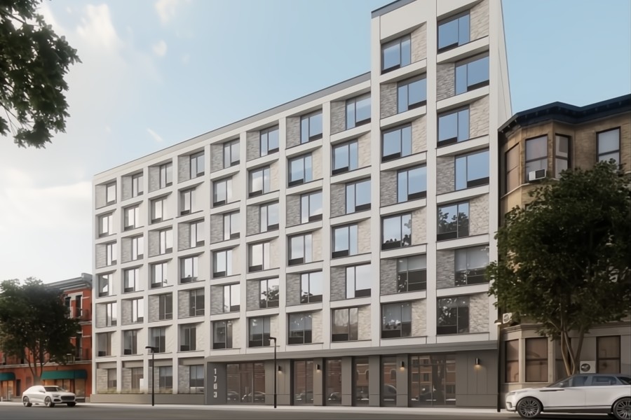 Source: Elmo realty
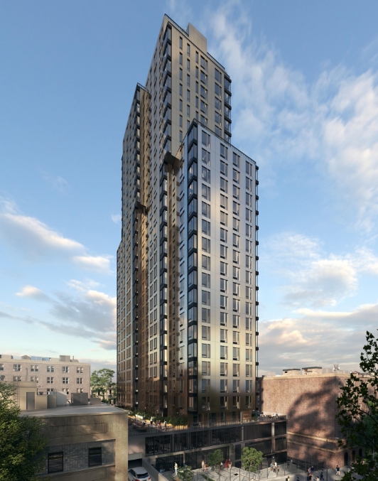
1440 Amsterdam Ave | Under Construction
Formerly a single-story grocery store destroyed by fire. Enabled by a land sale and air rights transfer from NYCHA. 30% of future units will be affordable. A new grocery store will be included as well.
| Google maps | https://maps.app.goo.gl/Wu6y5RZSNg1GAttw6 |
| BIN | 1059722 |
| Units | 480 |
| Zoning | R7-2 |
 Source: New York YIMBY
3560 Broadway: RKO Hamilton Theater | In Development
Historic theater in disrepair. MCB9 has previously collaborated with owner group Ashkenazy on developing a vision for the site that includes affordable housing, arts space, and theater restoration. Efforts stalled during the pandemic, but recently restarted with a task force led by Walter Alexander.
| Google maps | https://maps.app.goo.gl/pqz2gpoGjySpEnx36 |
| BIN | 1081831 |
| Zoning | R8 |
Source: Henson Architect
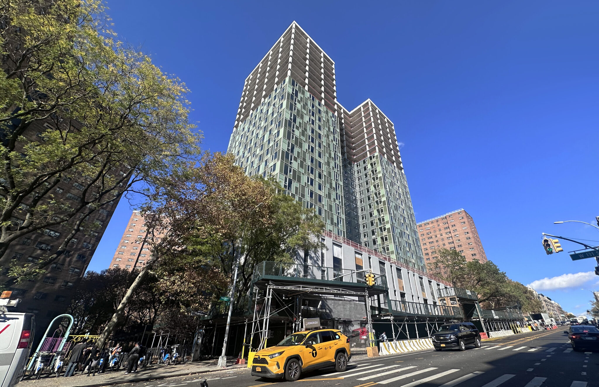
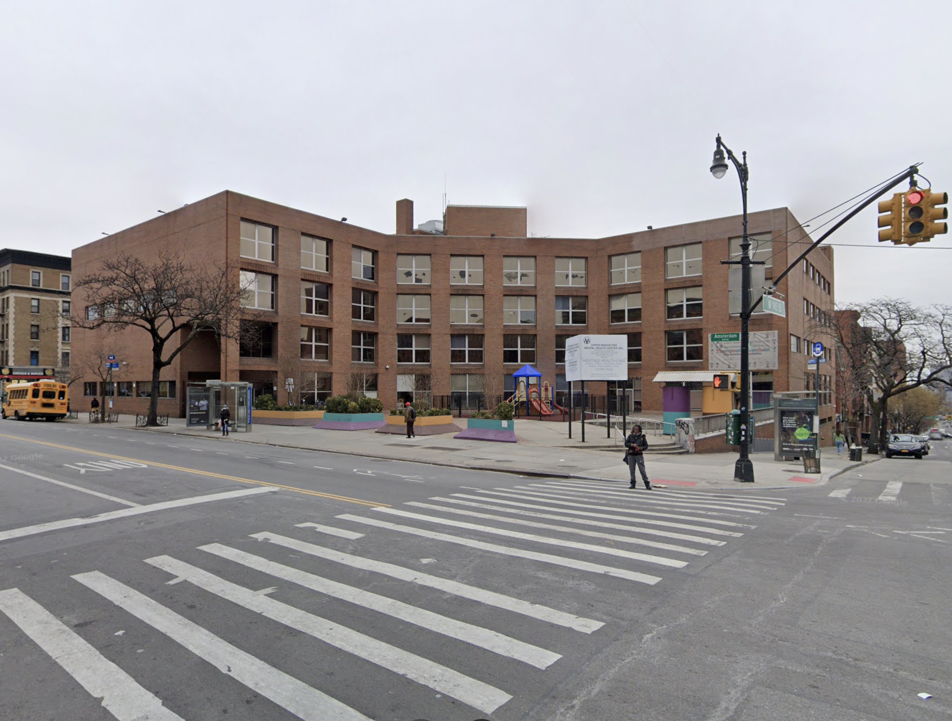
1727 Amsterdam Ave | In Development
NYC Health + Hospitals (HHC) proposes redeveloping this site (which previously housed Heritage Health and Emma Bowen health services) into supportive and affordable housing with ground-floor clinical space. MCB9 strongly opposes the current development, as HHC claims that it does not need to undergo the ULURP process–a claim MCB9 contests. The dispute remains ongoing (as of June 2025), with MCB9 threatening legal action over whether HHC properly transferred the land to the city. Senator Cordell Cleare has introduced bill S6685, which would explicitly require HHC sites to go through ULURP.
| Website (proposed development) | https://www.brc.org/hilltopapartments |
| Google maps | https://maps.app.goo.gl/stqxp5YLvYyZPS7o7 |
| BIN | 1061339 |
| Units | 201 |
| Zoning | R7A |
| MCB9 resolutions | June 2023, March 2025 |
 Source: BLDUP
633-641 W 142nd St | In Development
MCB9 rejected a ULURP application for the site in 2021, which would have upzoned it to R9A. 635-639 were demolished in 2023, despite MCB9’s objections. No actions since.
| Google maps | https://maps.app.goo.gl/w6ytNinXWNV8JiSP7 |
| BIN | 1062335, 1062351, 1062336, 1062337 |
| Zoning | R6A |
| ULURP | https://zap.planning.nyc.gov/projects/2019M0041 |
| MCB9 resolutions | May 2021, September 2023 |
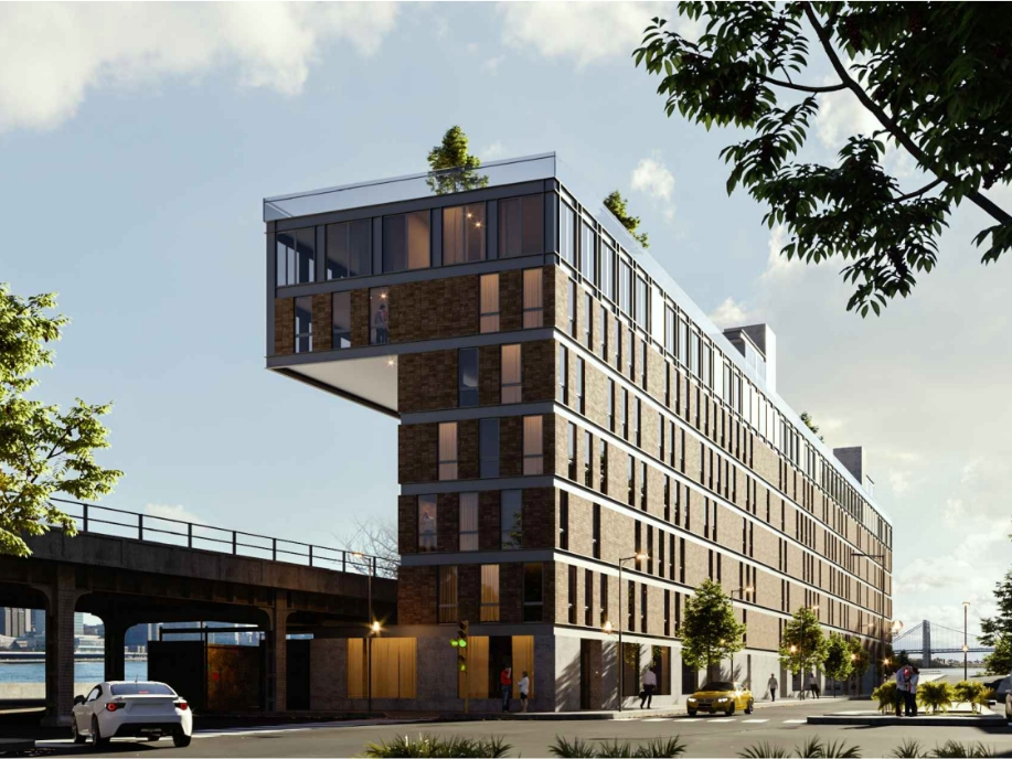
701 W 135th St (Crosscap ULURP / Amtrak cantilever building) | In Development
A proposal for a cantilevered building over Amtrak tracks. While MCB9 rejected the ULURP, all other parties approved it. Construction still requires Amtrak’s approval.
| Google maps | https://maps.app.goo.gl/T7fRjSi35WnMyqhM9 |
| BIN | 1061339 |
| Units | 60 |
| Zoning | R7-2 |
| ULURP | https://zap.planning.nyc.gov/projects/2022M0159 |
| MCB9 resolutions | June 2024 |
 Source: Crosscap
478 W 130th St | In Development
Permanently affordable housing, developed by Urban Resource Institute, in coordination with 487 W 129th St. MCB9 issued a Letter of Support for both sites in February 2025. Construction will proceed after the 129th building’s completion.
| Google maps | https://maps.app.goo.gl/JU91pVeoU4WNCwga7 |
| BIN | 1089706 |
| Units | 91 |
| Zoning | R7A |
487 W 129th St | In Development
Transitional housing for victims of domestic violence. MCB9 issued a Letter of Support in February 2025.
| Google maps | https://maps.app.goo.gl/y7QF9pv3LevBNciB7 |
| BIN | 1090853 |
| Units | 102 |
| Zoning | R7A |
16 Convent Ave | In Development
Currently a Verizon parking lot. Recently purchased with plans for construction under City of Yes UAP.
| Google maps | https://maps.app.goo.gl/LQCXT32Am1y7fyhk9 |
| BIN | 1812109 |
| Units | 75 |
| Zoning | R7A |
Annual statistics for CB9’s Statement of Needs
Each fall, every community board produces a Statement of Needs containing funding requests for city agencies. This is CB9’s document for FY26 (July 2025 - June 2026).
The document involves extensive research to produce a detailed accounting of district needs and characteristics. I helped the HLUZ committee pull relevant housing statistics for MCB9. Below, I’ll share how to compute these numbers, so pick up where I left off next year.
Rent burden, vacancy rate, median rents, median income
This Furman Center report contains neighborhood-level rental and income statistics. We generally include the following data points from the “Renters and Rent Conditions” table:
- Rental vacancy rate
- Moderately rent-burdened households
- Severely rent-burdened households
- Median rent, studios and 1-bedrooms
- Median rent, 2- and 3-bedrooms
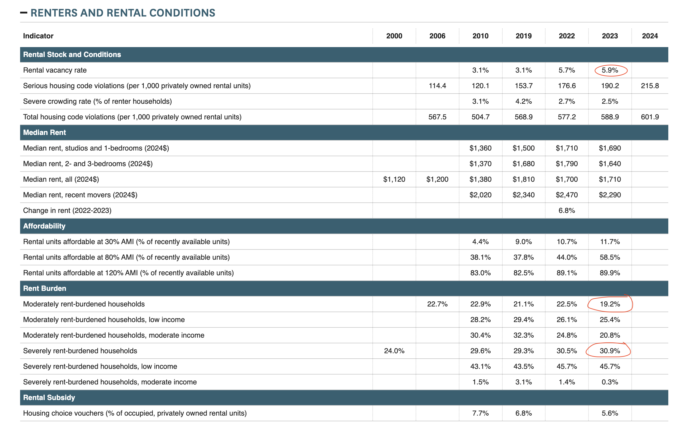
We also use this Zumper trend analysis to get median rents. It’s crucial to note the substantial divergence between data sources. Zumper reports the median studio rent at $3000, while the Furman Center reports $1690. This is likely because Zumper tracks new listings (mostly market-rate), while Furman analyzes existing rents (including stabilized units). Using both provides a more complete picture of the rental landscape.
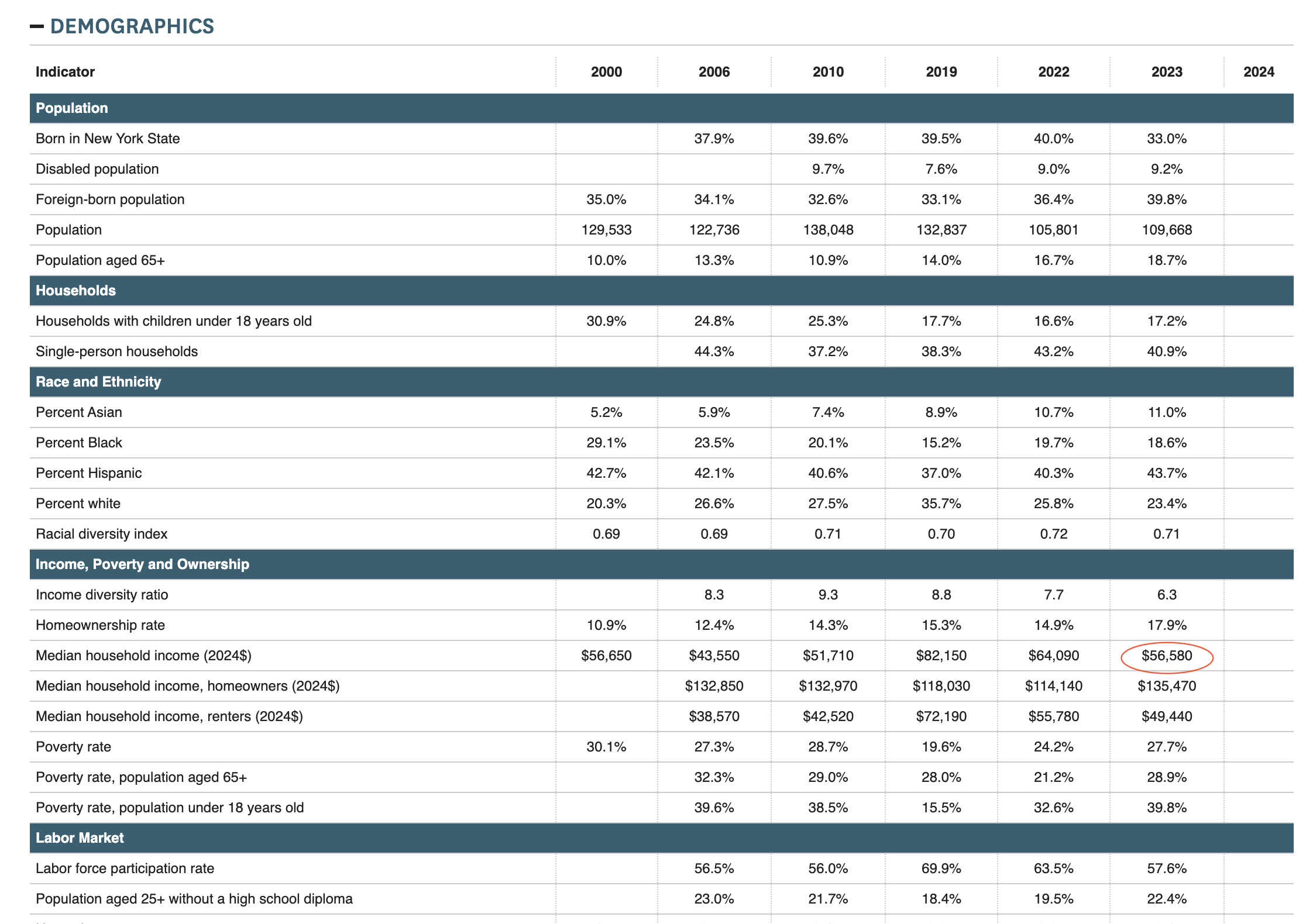
We additionally gather the median household income from the Furman “Demographics” table.
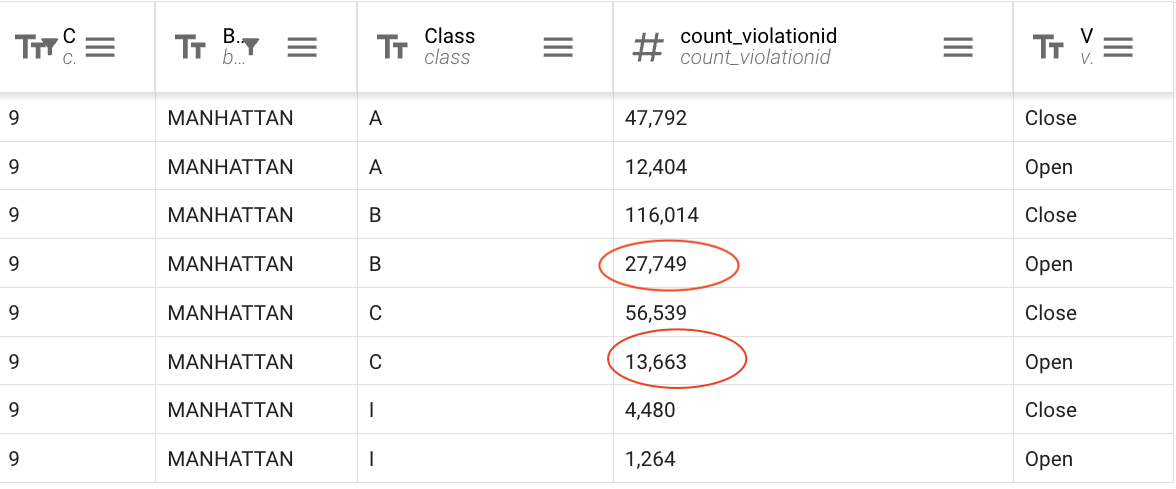
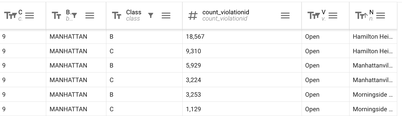
HPD violations
We track the number of open Class B and Class C violations in MCB9, which can be extracted from this OpenData table on Housing Maintenance Code Violations.
By setting up the right query logic, we can extract these numbers into a clear table:
- FILTER by “CommunityBoard” = “9” AND “Borough” = “MANHATTAN”
- GROUP by “CommunityBoard,” “Borough,” “Class,” “Violation Status”
- AGGREGATE by “ViolationID” count
The resulting table can be found at this URL and makes the numbers immediately available.
We also break down violations by neighborhood, by additionally grouping by “NTA.” This URL provides a table with that information.
Affordable units by income
This Affordable Housing Production by Building OpenData table provides everything needed to compute the number of recently completed affordable units in MCB9 and compare them with other districts. This URL points to a table that totals the number of units of varying affordability bars across each community district between 2014 and 2023. (Dates can be modified as needed.)
Wrap-up
Before moving on to Part 3, I want to share one more data source that I find useful for non-housing land use matters: Spatial Equity NYC. This tool visualizes key data points on the intersection of land use, public health, and transit, comparing them between districts. Here, you can explore average bus speeds, bike lane frequency, traffic fatality rates, and more.
This concludes the deep dive into resources for housing and land use. I’m happy to correct any omissions or mistakes; email me at claytonhsanford@gmail.com with any questions or comments.
The next section pivots to a more subjective direction and discusses the lessons I learned as a board member.